SeaView MAG
3D visualization and processing for magnetometer data.
3D visualization and processing for magnetometer data.
SeaView MAG is the first software solution specifically designed for marine magnetometer data processing featuring a wide set of tools for geotechnical applications, including UXO and pipeline surveys.
SeaView MAG is fully integrated with MAP, MOSAIC and SBP, allowing for a tighter multi-instrument dataset integration.
SeaView is designed to deliver the best performance possible, thanks to its 64 bit multi-threaded processing engine.
Thanks to its modern architecture, SeaView can process data interactively at full resolution, delivering the best output quality.
Powerful does not mean complicated. SeaView has a streamlined user interface which makes it intuitive and easy to use even to novice users.
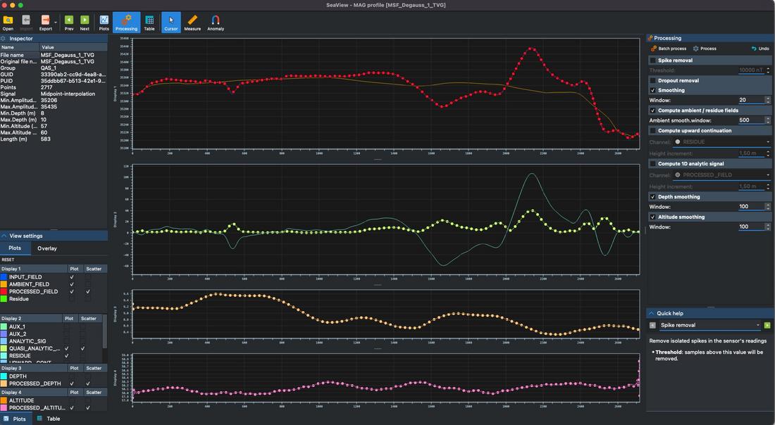
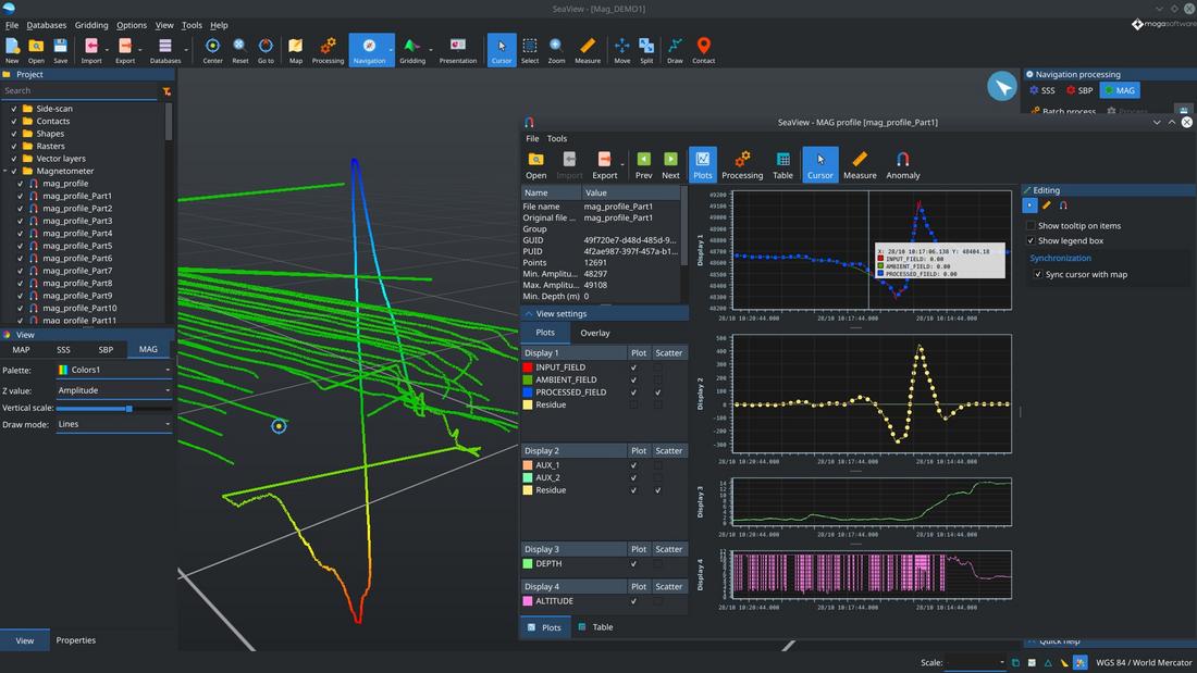
SeaView MAG can parse any text-based magnetometer logs with support for auxiliary channels and features built-in computing of ambient and residue fields, upward-continuation and analytic signal.
Experience a streamlined workflow for quasi-analytic and analytic signal processing, with tools for both manual and automatic anomalies picking.
SeaView MAG is full compatibile with OFG's Self Compensating Magnetometers (SCM) and Hypermag arrays, providing a streamlined user experience for processing and interpretation workflows.
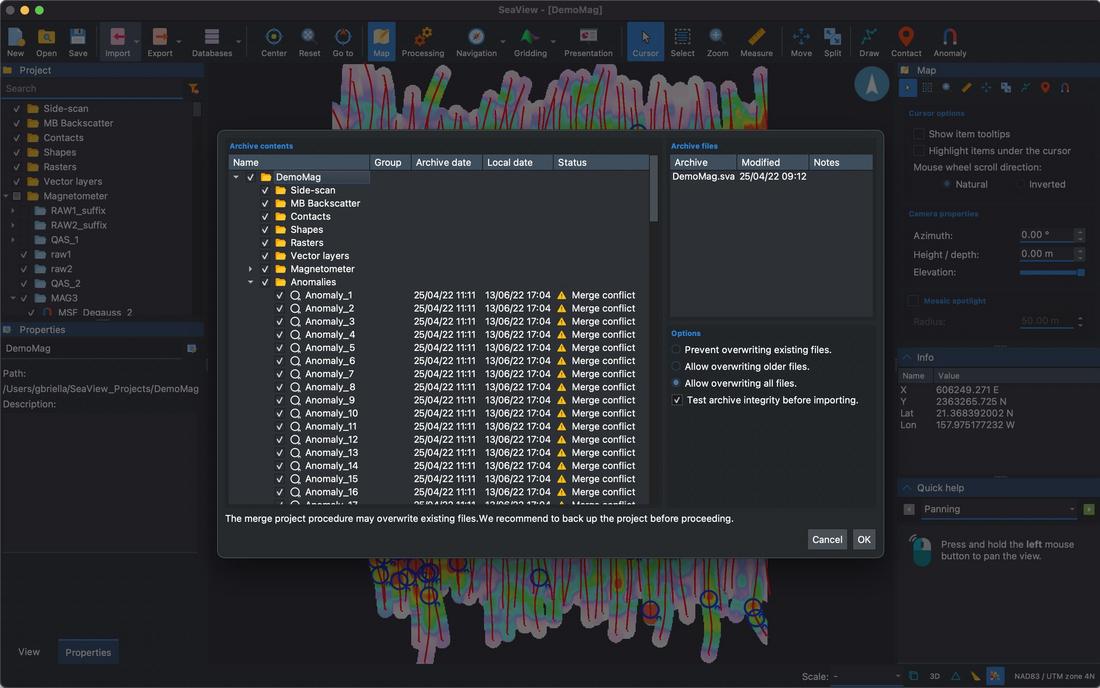
Provide daily updates to your client and onshore offices during operations with our incremental SeaView archives.
Internet speed won't be an issue anymore.
SeaView archives support password protection and digital signatures to detect and prevent data corruption.
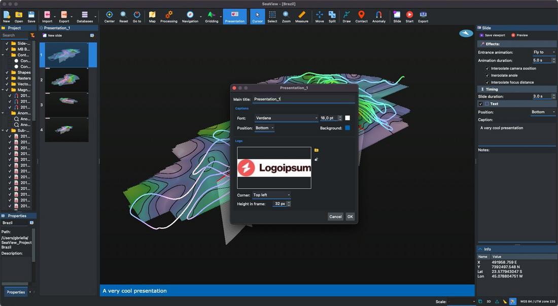
Create video presentations of your project with ease. Define keyframes, animations and captions with a few clicks.
Add your logo in video overlay to emphasize your corporate identity.
Play the presentation preview in SeaView or export it as a video in one click.
Learn more about the other modules in the SeaView suite or contact us for a free trial.
| Inputs | |
|---|---|
| MAG data | Text-based magnetometer logs with support for auxiliary channels. |
| GIS raster objects | GeoTIFF, KAP/BSB, NTF, GeoPackage, Arc/Info Binary and ASCII Grid, geo referenced PNG, JPG and WEBP and more |
| GIS vector objects | ESRI Shapefile, AutoCAD DXF, Google Earth KML/KMZ, GeoPackage, GPX, GeoJSON, CSV and more |
| Attachments | Geo-referenced document attachments for any file format |
| Outputs | |
| MAG | User-defined ASCII format including raw and processed data channels |
| GIS raster objects | GeoTIFF, KAP/BSB, NTF, GeoPackage, Arc/Info Binary and ASCII Grid, geo referenced PNG, JPG and WEBP and more |
| GIS vector objects | ESRI Shapefile, AutoCAD DXF, Google Earth KML/KMZ, GeoPackage, GPX, GeoJSON, CSV and more |
| Grids | XYZ grids generated from magnetometer data interpolation |
| Anomaly report | Automatic contact report generation in PDF |
| Data management | |
| Backup and sharing | Share and backup your data projects with SeaView Archives |
| Processing | |
| Data-agnostic | Extensive processing capabilities suitable for both raw sensor data or processed magnetometer profiles (e.g. residue data) |
| Input channel | Spikes and dropout removal, smoothing |
| Additional channels | Residue, ambient field, upward continuation and analytic signal computing for 1D profiles |
| User-defined channels | Custom data processing powered with SeaView Scripting |
| Processing history | Unlimited processing history with undo / redo and metadata (date and time, workstation name, description) |
| Batch processing | Apply processing sequences in batch to some or all profiles in a project |
| Gridding for UXO and pipelines | |
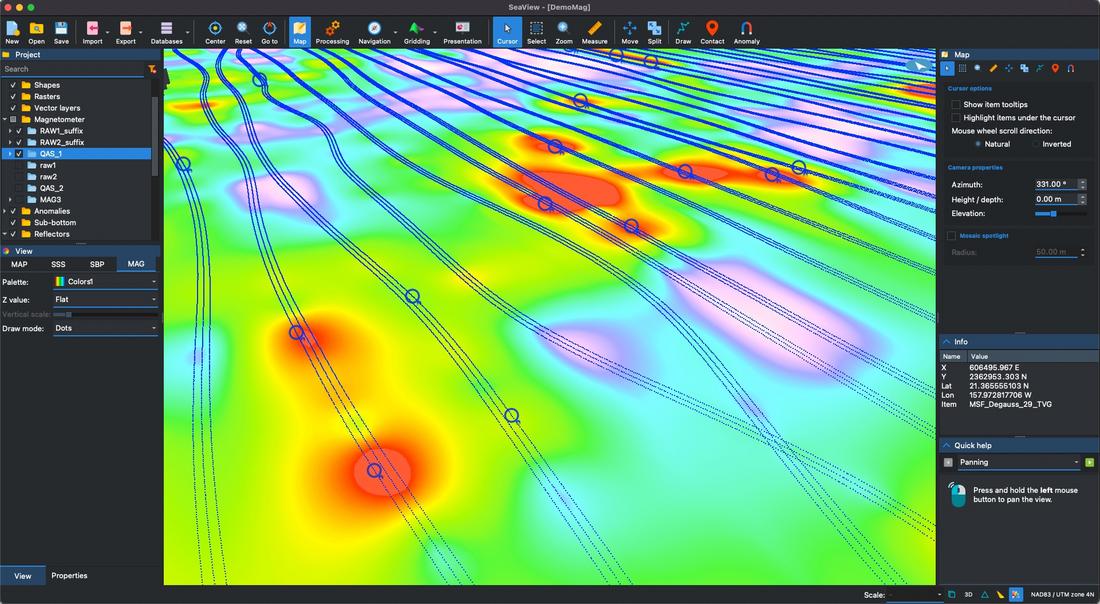
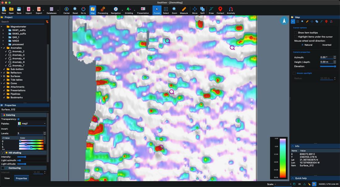
| Single-channel | Generate raster maps from any data channel (e.g. input field, residue, upward continuation) |
| Analytic signal | Simultaneous derivative and analytic signal map generation |
| TVG | Transverse gradiometer data processing: automatic dual sensor profile matching, midpoint-interpolation and 2D quasi-analytic signal map gridding |
| Navigation | |
| Processing | Automatic correct navigation computation for each data point with smoothing and layback correction |
| Processing history | Unlimited processing history with undo / redo and metadata (date and time, workstation name, description) |
| Batch processing | Apply processing sequences in batch to some or all profiles in a project |
| Interpretation | |
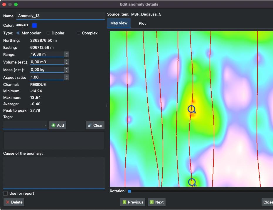
| Anomaly picking | Manual picking on 2D profiles or raster maps |
| Batch picking | Run automatic picking on multiple profiles in batch |
| 2D Display | |
| Multi-display | Easy comparison of different data channels with different vertical scale on sinchronized plot displays |
| Tracking cursor | 2D and 3D tracking cursor with optional views syncrhonization |
| Measurement tool | Interactive tool to extract minimum, maximum, average and peak-to-peak values from an interval of mag records |
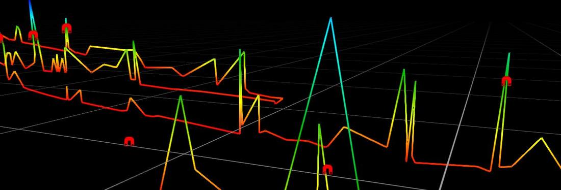
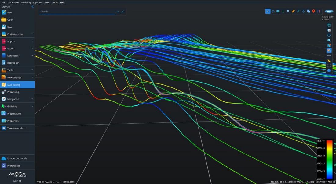
| 3D Display | |
| 3D overview | Display all the datasets in the project (including MOSAIC and SBP where present) |
| Interpretation | Pick anomalies on rasters derived by mag data gridding in the 3D view |
| Map tool tips | Show details of the object under the mouse cursor, including metadata |
| Measurement tool | Measure lengths and bearings in different units (meters, feet, miles, etc) |
| Bookmarks | User defined custom 3D views for easier navigation / presentation |
| Video presentations | Create animated videos with custom transitions and text overlays |
| System requirements | |
| Processor | 64 bit Intel CPU (or compatible), quad core, 2.5 GHz or faster. |
| RAM | 4 GB or more |
| Hard Disk | 2 GB free or more (SSD recommended) |
| Graphics card | GPU with at the least 4 GB of dedicated memory and compatible with OpenGL 4.1 or higher |
| Operating system | Windows 11 and Window 10 - Intel 64 bit, macOS High-Sierra or newer (both Intel and Apple Silicon supported), Linux 64 bit² |
| Licensing | |
| Virtual dongle | No physical dongle is required to run the software. |
| Cloud compatibility | Optional support for all major public cloud vendors² |
Notes