SeaView MOSAIC
High resolution interactive side scan sonar data processing and interpretation, fast and efficient.
High resolution interactive side scan sonar data processing and interpretation, fast and efficient.
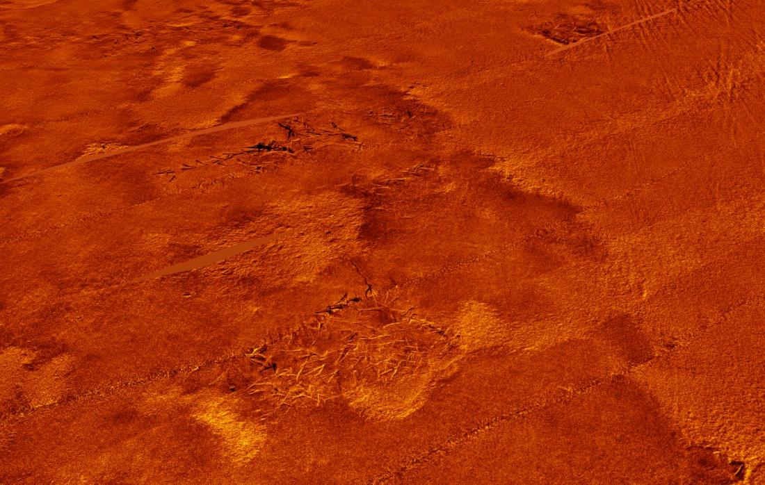
SeaView MOSAIC is the first post-processing and interpretation software for side-scan sonar capable of interactive mosaic editing at full resolution.
The software also features two novel algorithms: automatic normalization (AGC) and de-striping. These filters produce clean and crisp results, delivering high-resolution seafloor imagery with unmatched quality.
SeaView MOSAIC can export mosaic images at centimetre resolution in just a few minutes.
Manage large datasets (tens of TB) and interpretation databases (tens of thousands of contacts) with ease.
SeaView MOSAIC preserves the same resolution of the waterfall view into the final mosaic output.
Fully compatible with industry standards
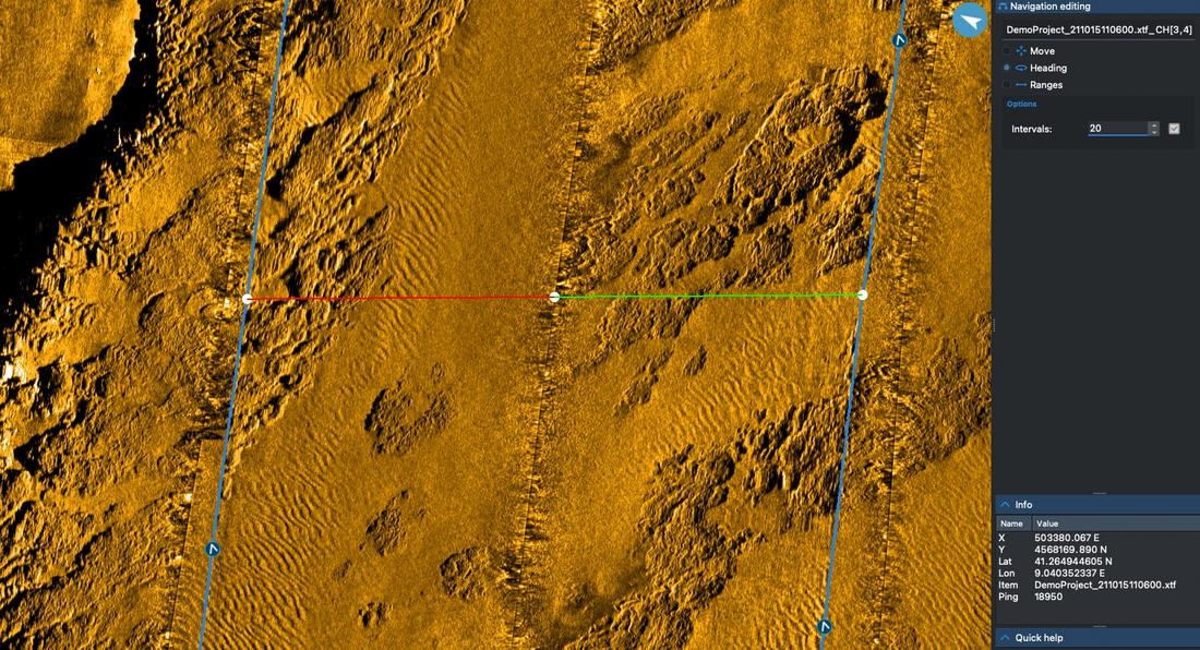
With SeaView you can remove repeated positions, filter heading values and apply layback corrections point by point.
Merging navigation logs into side-scan files recorded from AUVs is easy with our simple navigation import tool.
The advanced editing tools allow you to fix complex navigation issues interactively: adjust position and heading or cut ranges by hand.
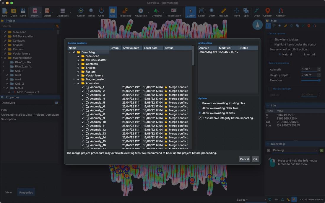
Provide daily updates to your client and onshore offices during operations with our incremental SeaView archives.
Internet speed won't be an issue anymore.
SeaView archives support password protection and digital signatures to detect and prevent data corruption.
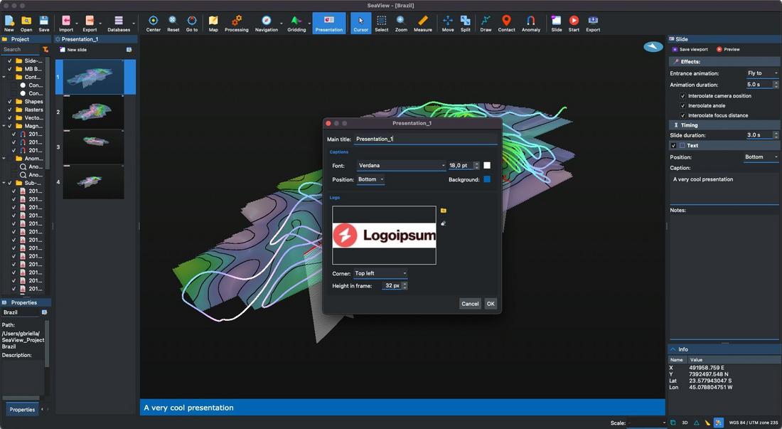
Create video presentations of your project with ease. Define keyframes, animations and captions with a few clicks.
Add your logo in video overlay to emphasize your corporate identity.
Play the presentation preview in SeaView or export it as a video in one click.
Learn more about the other modules in the SeaView suite or contact us for a free trial.
| Inputs | |
|---|---|
| Side-scan data | Triton XTF; Edgetech JSF, Klein SDF, RESON S7K, Starfish logdoc, Kraken TIL, Humminbird SON¹, Lowrance SL2/SL3¹, Solstice SWF8/32, Deepvision DVS, Marine sonic SDS |
| GIS raster objects | GeoTIFF, KAP/BSB, NTF, GeoPackage, Arc/Info Binary and ASCII Grid, geo referenced PNG, JPG and WEBP and more |
| GIS vector objects | ESRI Shapefile, AutoCAD DXF, Google Earth KML/KMZ, GeoPackage, GPX, GeoJSON, CSV and more |
| Attachments | Geo-referenced document attachments for any file format |
| Outputs | |
| Side-scan data | XTF output processed or RAW data |
| GIS raster objects | GeoTIFF, KAP/BSB, NTF, GeoPackage, Arc/Info Binary and ASCII Grid, geo referenced PNG, JPG and WEBP and more |
| GIS vector objects | ESRI Shapefile, AutoCAD DXF, Google Earth KML/KMZ, GeoPackage, GPX, GeoJSON, CSV and more |
| Navigation | Export processed navigation as GIS vector object |
| Mosaic images | High resolution geo-referenced mosaic output with optional tiled and single lines options and support for user defined clipping areas |
| Waterfall images | Batch export waterfall images with annotations (grid lines and contacts) |
| Contact report | Automatic contact report generation in PDF, with contact images preview, custom logo and page header/footer |
| Contact images | Batch export contact images with user defined annotations |
| Data management | |
| Backup and sharing | Share and backup your data projects with SeaView Archives |
| Processing | |
| Backscatter | Automatic radiometric correction, De-striping, TVG, Gain, DC removal, Slant range correction, Spikes removal |
| Default settings | Perform backscatter processing on data import with predefined settings |
| Import/Export settings | Share or backup your processing settings through simple files |
| Processing history | Unlimited processing history with undo / redo and metadata (date and time, workstation name, description) |
| Batch processing | Apply processing sequences in batch to some or all lines in a project |
| Navigation | |
| Processing | Automatic correct navigation computation for each trace, spikes removal, rectification, smoothing, feathering compensation, layback, compute and filter CMG, GPS offsets |
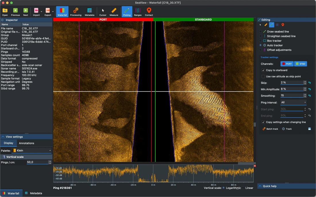
| Manual editing | Interactive manual editing in 2D/3D view of positioning, heading and ranges |
| Default settings | Perform navigation processing on data import with predefined settings |
| Import/Export settings | Share or backup your processing settings through simple files |
| Processing history | Unlimited processing history with undo / redo and metadata (date and time, workstation name, description) |
| Batch processing | Apply processing sequences in batch to some or all lines in a project |
| Batch import | Import positioning information from navigation log(s) on multiple lines at once |
| Clone navigation | Copy processed navigation and bottom track from one line to another, e.g. from high-frequency to low-frequecy or viceversa. |
| Interpretation | |
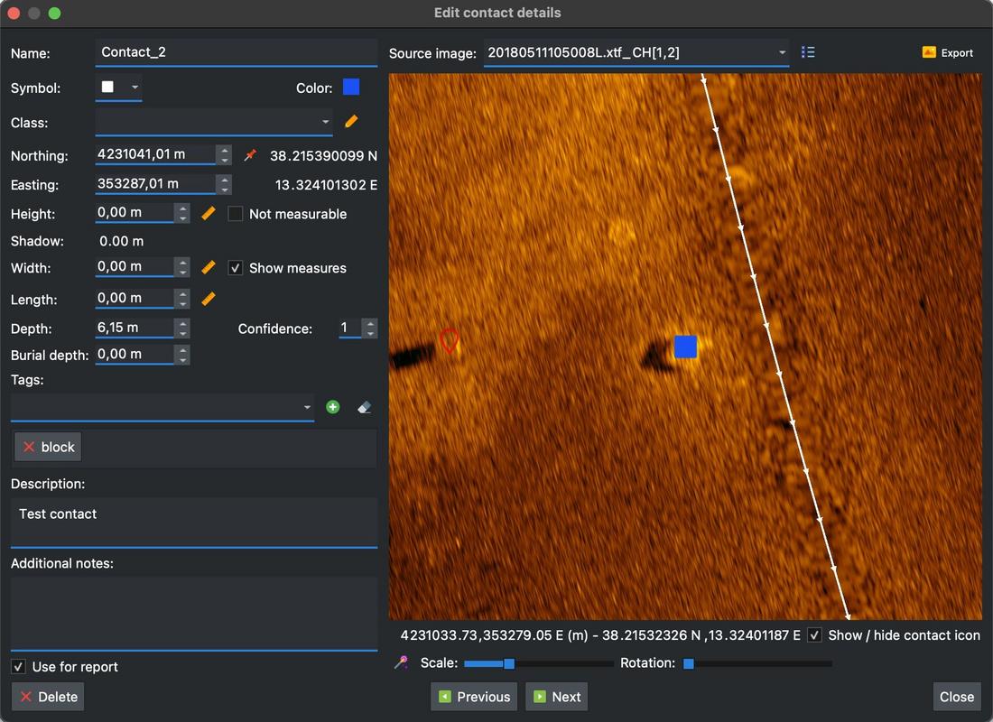
| Contact picking | Advanced contacts database with geo-referencing, depths, measurements and custom classes and tags |
| SSDM support | Support for custom Seabed Survey Data Model (SSDM) |
| Batch processing | Run automatic bottom tracking on multiple lines in batch |
| Shapes | Draw polylines, polygons and placemarks to annotate the mosaic and compute lengths and areas automatically |
| 2D Display | |
| View options | Advanced 2D viewer with user defined scales, annotations, color palettes instant display gain and interactive zoom / pan controls |
| Backscatter plot | Display amplitude plot with linear or logarithmic (dB) scale |
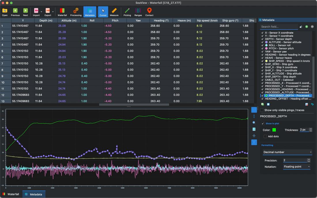
| QC plots | User defined plots from metadata |
| Sync windows | Sync cursor movements across multiple 2D windows and the 3D view |
| Measurement tool | Measure lengths, bearings and heights in different units (meters, feet, miles, etc) |
| Range editing | Draw range lines by hand or use the automatic range finder |
| 3D Display | |
| 3D overview | Display all the datasets in the project (including SBP and MAG where present) |
| Interactive editing | Edit navigation, split datasets, edit visible extents and enable draping |
| Transparency controls | Adjust transparency individually for each line or globally for the entire mosaic |
| Interpretation | Pick contacts on side-scan lines in the 3D view |
| Tracking cursor | 3D tracking cursor with optional views syncrhonization |
| Map tool tips | Show details of the object under the mouse cursor, including metadata |
| Measurement tool | Measure lengths and bearings in different units (meters, feet, miles, etc) |
| Bookmarks | User defined custom 3D views for easier navigation / presentation |
| Video presentations | Create animated videos with custom transitions and text overlays |
| System requirements | |
| Processor | 64 bit Intel CPU (or compatible), quad core, 2.5 GHz or faster. |
| RAM | 4 GB or more |
| Hard Disk | 2 GB free or more (SSD recommended) |
| Graphics card | GPU with at the least 4 GB of dedicated memory and compatible with OpenGL 4.1 or higher |
| Operating system | Windows 11 and Window 10 - Intel 64 bit, macOS High-Sierra or newer (both Intel and Apple Silicon supported), Linux 64 bit² |
| Licensing | |
| Virtual dongle | No physical dongle is required to run the software. |
| Cloud compatibility | Optional support for all major public cloud vendors³ |
Notes